FUSAR-KLIP: Towards Multimodal Foundation Models for Remote Sensing
作者: Yi Yang, Xiaokun Zhang, Qingchen Fang, Jing Liu, Ziqi Ye, Rui Li, Li Liu, Haipeng Wang
分类: cs.CV
发布日期: 2025-09-28 (更新: 2026-01-23)
💡 一句话要点
提出FUSAR-KLIP以解决遥感图像理解中的认知不一致问题
🎯 匹配领域: 支柱七:动作重定向 (Motion Retargeting) 支柱九:具身大模型 (Embodied Foundation Models)
关键词: 遥感图像理解 合成孔径雷达 多模态基础模型 知识引导学习 自一致优化机制
📋 核心要点
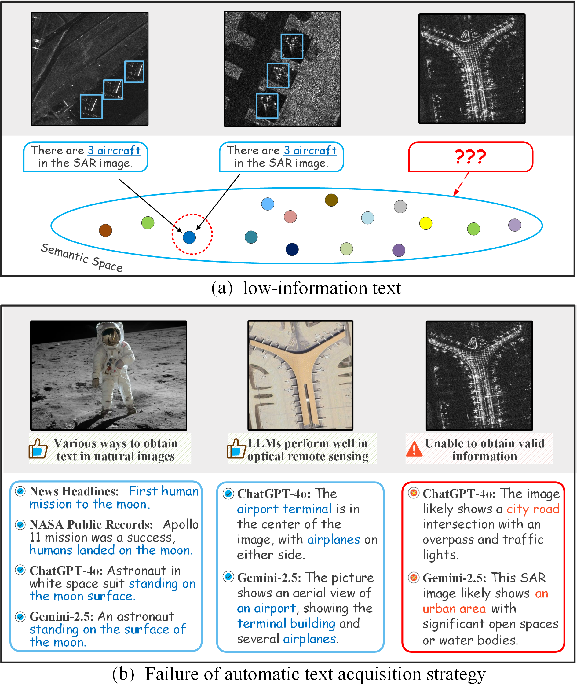
- 现有的跨模态模型在遥感图像理解中面临认知不一致的问题,尤其是SAR图像的特殊性使得传统方法难以适用。
- 本文提出FUSAR-KLIP,通过构建大规模SAR数据集和知识引导的学习机制,解决了遥感图像的理解问题。
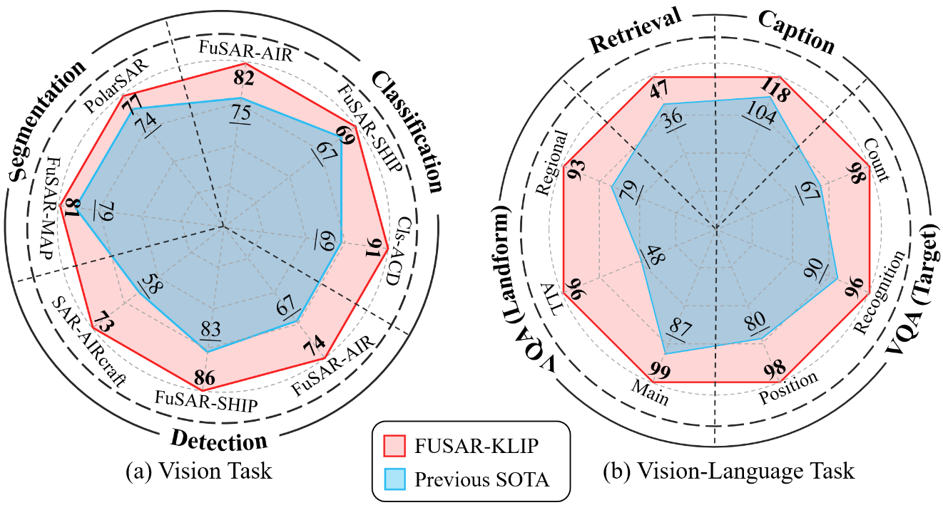
- 实验表明,FUSAR-KLIP在11个下游任务中表现优异,相较于15个主流基础模型有显著提升。
📝 摘要(中文)
跨模态人工智能在一般图像理解中取得了显著成功,但在遥感图像解读中存在认知不一致的问题。遥感图像需要深厚的地球科学理解,尤其是在合成孔径雷达(SAR)图像中,因其成像机制的特殊性,导致与一般图像存在显著的模态异质性。为了解决这一问题,本文提出了FUSAR-KLIP,这是首个知识引导的多模态基础模型,构建了大规模SAR数据集FUSAR-GEOVL-1M,并设计了自一致的迭代优化机制,建立了统一的评估基准。
🔬 方法详解
问题定义:本文旨在解决遥感图像,特别是合成孔径雷达(SAR)图像理解中的认知不一致问题。现有方法在处理SAR图像时缺乏深厚的地球科学知识,导致理解效果不佳。
核心思路:FUSAR-KLIP通过知识引导的方式,结合多模态学习,旨在使模型能够更好地理解SAR图像的地理和空间特征。通过构建大规模数据集和自一致的优化机制,提升模型的认知能力。
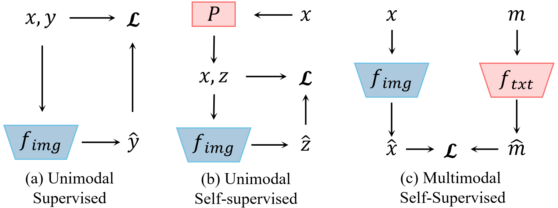
技术框架:整体框架包括数据集构建、知识编码、跨模态学习和评估基准四个主要模块。首先构建FUSAR-GEOVL-1M数据集,然后通过层次认知链生成结构化文本,最后在自监督闭环中进行学习和优化。
关键创新:最重要的创新在于提出了知识引导的自一致迭代优化机制,使得模型在学习过程中能够与人类认知和物理法则保持一致,显著提升了跨模态学习的效果。
关键设计:在模型设计中,采用了对比、匹配和重建的损失函数,确保了知识信息的有效传递,同时在数据集构建中涵盖了120,000幅图像和135个城市的地理投影属性。
🖼️ 关键图片
📊 实验亮点
实验结果显示,FUSAR-KLIP在11个典型下游任务中表现优异,相较于15个主流基础模型,整体性能提升显著,尤其在SAR图像的理解和应用场景中,展示了其强大的跨模态学习能力。
🎯 应用场景
该研究的潜在应用领域包括环境监测、城市规划、灾害评估等遥感相关领域。通过提升SAR图像的理解能力,FUSAR-KLIP能够为科学研究和实际应用提供更精准的数据支持,推动遥感技术的发展与应用。未来,该模型有望在更广泛的多模态学习任务中发挥重要作用。
📄 摘要(原文)
Cross-modal artificial intelligence, represented by visual language models, has achieved significant success in general image understanding. However, a fundamental cognitive inconsistency exists between general visual representation and remote sensing image interpretation: remote sensing images couple topography, terrain, and spatial structure, thereby inherently requiring models to possess deep geoscientific understanding. This cognitive difference is further amplified in synthetic aperture radar (SAR) imagery: while SAR possesses irreplaceable all-weather, all-day observation capabilities, it is constrained by coherent imaging mechanisms, exhibiting significant modal heterogeneity with general images. To address this inconsistency, we propose FUSAR-KLIP, the first knowledge-guided general multimodal foundational model for SAR, along with reusable data and evaluation baselines. Specifically: (1) FUSAR-GEOVL-1M (the first large-scale SAR dataset with complete geographic projection attributes) was constructed, covering multiple satellite platforms, 120,000 images, and 135 cities; (2) Aligned structured text was generated through hierarchical cognitive thought chains, accurately encoding more than 1 million multidimensional semantic information from geomorphological environment and regional attributes to spatial relationships; (3) A self-consistent iterative optimization mechanism was designed to guide cross-modal learning with this knowledge information consistent with human cognition and physical laws in a self-supervised closed loop consisting of contrast, matching, and reconstruction; (4) A unified evaluation benchmark was established in 11 typical downstream tasks in the two major categories of vision and language, and compared with 15 mainstream foundation models.