Decadal analysis of sea surface temperature patterns, climatology, and anomalies in temperate coastal waters with Landsat-8 TIRS observations
作者: Yiqing Guo, Nagur Cherukuru, Eric Lehmann, Xiubin Qi, Mark Doubelld, S. L. Kesav Unnithan, Ming Feng
分类: physics.ao-ph, cs.CV, eess.IV, eess.SP, physics.geo-ph
发布日期: 2025-03-07 (更新: 2025-05-13)
备注: Submitted to GIScience & Remote Sensing
💡 一句话要点
利用Landsat-8 TIRS数据分析南澳大利亚沿海海面温度时空模式与异常
🎯 匹配领域: 支柱八:物理动画 (Physics-based Animation)
关键词: 海面温度 Landsat-8 TIRS 遥感 气候学 异常检测 沿海研究 南澳大利亚
📋 核心要点
- 现有粗分辨率热传感器难以捕捉沿海地区精细的海面温度(SST)模式,限制了对沿海生态系统的理解。
- 本研究利用Landsat-8 TIRS的100米分辨率数据,开发了SST检索方法,构建了高分辨率的SST气候学数据。
- 研究结果验证了卫星数据的准确性,揭示了南澳大利亚沿海SST的时空模式和异常事件,为渔业和水产养殖提供支持。
📝 摘要(中文)
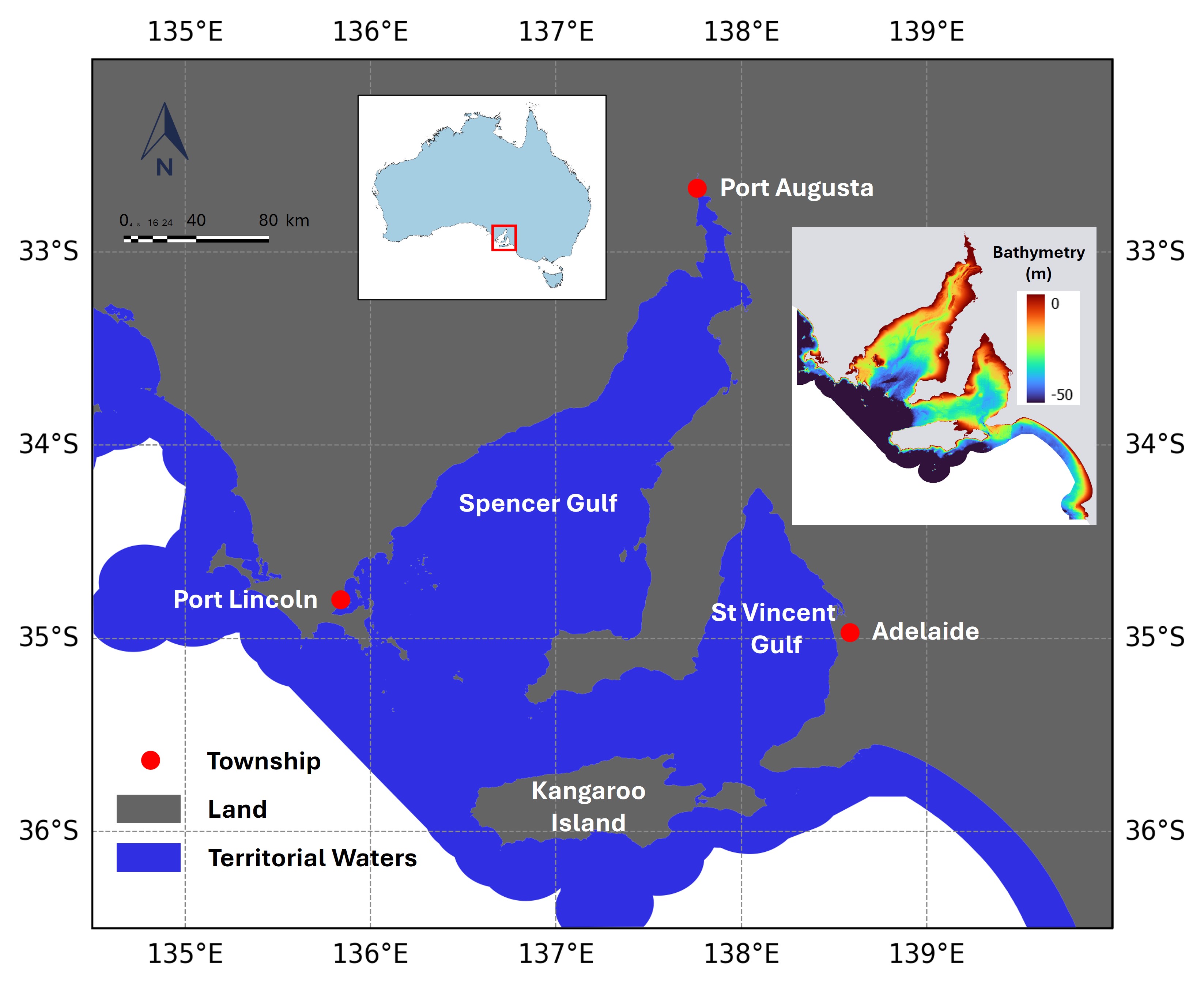
海面温度(SST)是表征海面热状态的基本物理参数。由于陆地、海洋和大气之间复杂的相互作用,沿海水域的SST空间梯度通常比开阔海域更精细。搭载于Landsat-8上的热红外传感器(TIRS)具有100米的空间分辨率,为揭示传统粗分辨率热传感器容易忽略的精细沿海SST模式提供了独特的机会。本研究首先通过开发一种从Landsat-8 TIRS传感器检索SST的有效方法,分析了2014年至2023年南澳大利亚温带沿海水域SST的时空模式。在南澳大利亚林肯港附近部署了一个浮标,以验证SST检索的质量。然后,构建了100米分辨率的每日基线SST气候学数据,从而可以检测和分析异常SST事件。结果表明:(1)卫星衍生的SST数据与原位测量的SST值吻合良好;(2)斯宾塞湾上部和圣文森特湾上部的半封闭浅水区域在夏季表现出较高的温度,在冬季表现出较低的温度,高于靠近开阔海洋的水域,导致SST的季节性变化更大;(3)与研究区域的其他区域相比,斯宾塞湾和圣文森特湾的近岸浅水区以及袋鼠岛周围的区域被确定为具有更高的SST异常概率;(4)异常SST事件更可能发生在温暖的月份而不是凉爽的月份。希望这些发现有助于支持南澳大利亚沿海水域的渔业和水产养殖业。
🔬 方法详解
问题定义:论文旨在解决利用低空间分辨率卫星数据难以准确分析沿海地区精细海面温度(SST)模式的问题。现有方法无法有效捕捉沿海地区复杂的热力学特征,限制了对该区域海洋环境的监测和管理。
核心思路:论文的核心思路是利用Landsat-8 TIRS传感器提供的高空间分辨率(100米)热红外数据,开发一种可靠的SST检索方法,从而能够更精细地分析沿海SST的时空变化和异常事件。通过构建高分辨率的SST气候学数据,可以更好地识别和理解沿海区域的海洋热力学特征。
技术框架:该研究的技术框架主要包括以下几个阶段:1) Landsat-8 TIRS数据的获取和预处理;2) 开发SST检索算法,将卫星数据转换为SST值;3) 利用浮标数据验证SST检索的准确性;4) 基于2014-2023年的SST数据,构建每日基线SST气候学数据;5) 分析SST的时空模式和异常事件,并识别高风险区域。
关键创新:该研究的关键创新在于利用Landsat-8 TIRS的高分辨率数据,克服了传统低分辨率数据在沿海SST分析中的局限性。通过构建高分辨率的SST气候学数据,能够更准确地识别和分析沿海区域的SST异常事件,为海洋环境监测和管理提供更可靠的数据支持。
关键设计:论文的关键设计包括:1) 选择合适的SST检索算法,并针对Landsat-8 TIRS数据进行优化;2) 利用浮标数据进行严格的SST验证,确保数据的准确性;3) 构建每日基线SST气候学数据,用于检测和分析SST异常事件;4) 采用统计方法分析SST的时空模式和异常概率。
🖼️ 关键图片


📊 实验亮点
研究结果表明,卫星衍生的SST数据与实测数据吻合良好,验证了SST检索方法的准确性。研究还发现,斯宾塞湾和圣文森特湾的半封闭浅水区域具有更高的季节性SST变化,近岸浅水区和袋鼠岛周围区域具有更高的SST异常概率。此外,SST异常事件更可能发生在温暖月份。
🎯 应用场景
该研究成果可应用于沿海渔业和水产养殖业,帮助优化养殖区域选择,预测潜在的海洋热浪风险,并为海洋环境保护提供科学依据。高分辨率SST数据还可用于气候变化研究,评估沿海生态系统对气候变化的响应,并为制定适应性管理策略提供支持。
📄 摘要(原文)
Sea surface temperature (SST) is a fundamental physical parameter characterising the thermal state of sea surface. Due to the intricate thermal interactions between land, sea, and atmosphere, the spatial gradients of SST in coastal waters often appear at finer spatial scales than those in open ocean waters. The Thermal Infrared Sensor (TIRS) onboard Landsat-8, with its 100-meter spatial resolution, offers a unique opportunity to uncover fine-scale coastal SST patterns that would otherwise be overlooked by coarser-resolution thermal sensors. In this study, we first analysed the spatiotemporal patterns of SST in South Australia's temperate coastal waters from 2014 to 2023 by developing an operational approach for SST retrieval from the Landsat-8 TIRS sensor. A buoy was deployed off the coast of Port Lincoln, South Australia, to validate the quality of SST retrievals. Then the daily baseline climatology of SST with 100 m resolution was constructed, which allowed for the detection and analysis of anomalous SST events. Our results suggest the following: (1) the satellite-derived SST data aligned well with the in-situ measured SST values; (2) the semi-enclosed, shallow regions of Upper Spencer Gulf and Upper St Vincent Gulf showed higher temperatures during summer and cooler temperatures during winter than waters closer to the open ocean, resulting in a higher seasonal variation in SST; (3) the near-shore shallow areas in Spencer Gulf and St Vincent Gulf, and regions surrounding Kangaroo Island, were identified to have a higher probability of SST anomalies compared to the rest of the study area; and (4) anomalous SST events were more likely to happen during the warm months than the cool months. We hope these findings would be helpful in supporting the fishing and aquaculture industries in the coastal waters of South Australia.