MapAgent: A Hierarchical Agent for Geospatial Reasoning with Dynamic Map Tool Integration
作者: Md Hasebul Hasan, Mahir Labib Dihan, Tanzima Hashem, Mohammed Eunus Ali, Md Rizwan Parvez
分类: cs.AI
发布日期: 2025-09-07 (更新: 2025-10-14)
备注: 27 Pages
🔗 代码/项目: GITHUB
💡 一句话要点
提出MapAgent,用于动态地图工具集成和地理空间推理的分层Agent框架
🎯 匹配领域: 支柱九:具身大模型 (Embodied Foundation Models)
关键词: 地理空间推理 多Agent系统 地图工具集成 分层架构 大语言模型 Agent框架 空间推理 地图API
📋 核心要点
- 现有Agent框架在地理空间任务中面临空间推理、多跳规划和实时地图交互的挑战。
- MapAgent采用分层多Agent架构,将复杂查询分解为子目标,并使用专用模块和地图工具Agent进行处理。
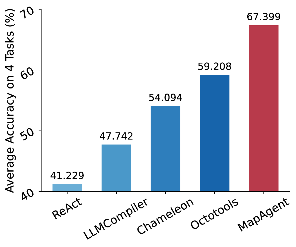
- 实验结果表明,MapAgent在多个地理空间基准测试中显著优于现有工具增强和Agent基线。
📝 摘要(中文)
本文提出MapAgent,一个分层的多Agent即插即用框架,具有定制的工具集和Agent支架,用于地图集成的地理空间推理。现有框架主要针对数学、编码或Web自动化等领域,在需要空间推理、多跳规划和实时地图交互的地理空间任务中表现不足。MapAgent将规划与执行分离,高层规划器将复杂查询分解为子目标,并路由到专门的模块。对于工具繁重的模块(如基于地图的服务),设计了一个专用的地图工具Agent,自适应地并行协调相关API,以有效地获取与查询相关的地理空间数据。简单的模块(如解决方案生成或答案提取)则无需额外的Agent开销。在四个不同的地理空间基准测试(MapEval-Textual、MapEval-API、MapEval-Visual和MapQA)上评估了MapAgent,结果表明,相对于最先进的工具增强和Agent基线,MapAgent取得了显著的提升。
🔬 方法详解
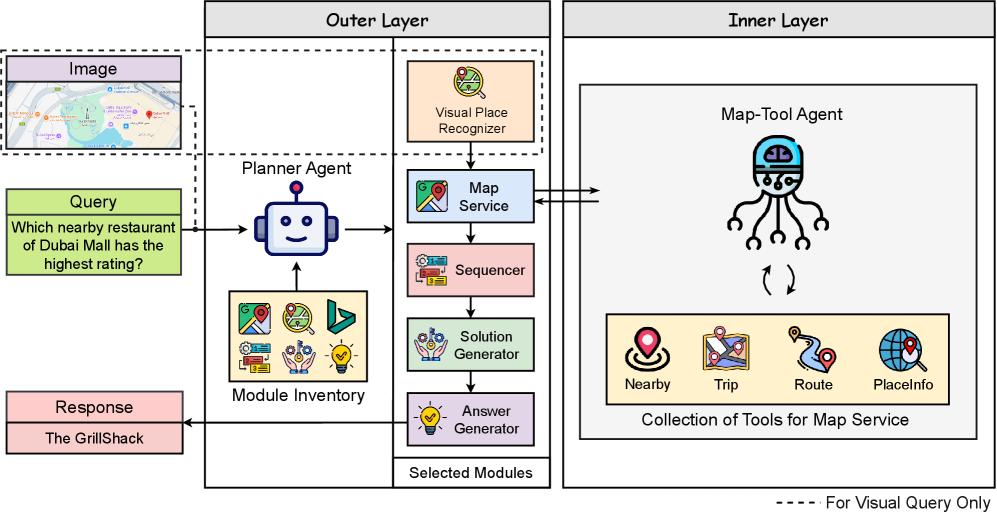
问题定义:现有的大语言模型(LLM)Agent框架在处理地理空间任务时,由于缺乏对空间推理、多跳规划以及实时地图交互能力的支持,表现不佳。特别是在需要频繁调用地图API的任务中,LLM容易被大量相似但略有不同的API所淹没,导致工具选择的准确性降低。
核心思路:MapAgent的核心思路是将复杂的地理空间推理任务分解为多个子任务,并采用分层Agent架构来分别处理这些子任务。通过将规划与执行分离,并为地图相关的API调用设计专门的Agent,从而降低LLM的认知负担,提高工具选择的准确性和效率。
技术框架:MapAgent采用分层多Agent框架,包含一个高层规划器和多个专门的模块。高层规划器负责将复杂的地理空间查询分解为子目标,并将这些子目标路由到相应的模块进行处理。对于需要频繁调用地图API的模块,会使用一个专门的地图工具Agent来协调相关的API调用。其他模块,如解决方案生成或答案提取,则直接由LLM处理,无需额外的Agent开销。
关键创新:MapAgent的关键创新在于其分层Agent架构和专门的地图工具Agent设计。分层架构能够有效地分解复杂任务,降低LLM的认知负担。地图工具Agent能够自适应地并行协调相关的地图API调用,提高数据获取的效率和准确性。与现有的扁平Agent架构相比,MapAgent能够更好地处理复杂的地理空间推理任务。
关键设计:MapAgent的设计重点在于如何有效地分解任务和协调地图API调用。高层规划器的设计需要考虑到不同子任务之间的依赖关系和优先级。地图工具Agent的设计需要考虑到不同地图API的功能和参数,以及如何根据查询的需求选择合适的API进行调用。具体的参数设置、损失函数和网络结构等技术细节在论文中未详细说明,属于未知信息。
🖼️ 关键图片

📊 实验亮点
MapAgent在四个不同的地理空间基准测试(MapEval-Textual、MapEval-API、MapEval-Visual和MapQA)上进行了评估,实验结果表明,MapAgent相对于最先进的工具增强和Agent基线取得了显著的性能提升。具体的性能数据和提升幅度在论文中未给出详细的数值,属于未知信息。
🎯 应用场景
MapAgent可应用于多种需要地理空间推理和地图交互的场景,例如智能导航、位置服务、城市规划、环境监测和灾害管理。该框架能够帮助用户更有效地利用地图数据,解决复杂的地理空间问题,并为相关领域的决策提供支持。未来,MapAgent可以进一步扩展到其他领域,例如自动驾驶和机器人导航。
📄 摘要(原文)
Agentic AI has significantly extended the capabilities of large language models (LLMs) by enabling complex reasoning and tool use. However, most existing frameworks are tailored to domains such as mathematics, coding, or web automation, and fall short on geospatial tasks that require spatial reasoning, multi-hop planning, and real-time map interaction. To address these challenges, we introduce MapAgent, a hierarchical multi-agent plug-and-play framework with customized toolsets and agentic scaffolds for map-integrated geospatial reasoning. Unlike existing flat agent-based approaches that treat tools uniformly-often overwhelming the LLM when handling similar but subtly different geospatial APIs-MapAgent decouples planning from execution. A high-level planner decomposes complex queries into subgoals, which are routed to specialized modules. For tool-heavy modules-such as map-based services-we then design a dedicated map-tool agent that efficiently orchestrates related APIs adaptively in parallel to effectively fetch geospatial data relevant for the query, while simpler modules (e.g., solution generation or answer extraction) operate without additional agent overhead. This hierarchical design reduces cognitive load, improves tool selection accuracy, and enables precise coordination across similar APIs. We evaluate MapAgent on four diverse geospatial benchmarks-MapEval-Textual, MapEval-API, MapEval-Visual, and MapQA-and demonstrate substantial gains over state-of-the-art tool-augmented and agentic baselines. We open-source our framwork at https://github.com/Hasebul/MapAgent.